
Monday, March 19, 2018
Jacksonville, Alabama Tornado
We just had one very significant tornadoes that hit Jacksonville, Alabama about 15 minutes ago. It looks like another circulation is about to go though Jacksonville AGAIN so that's a double dip for them in the past few minutes. Think good thoughts for northern Alabama tonight.


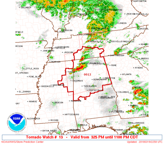
PDS Tornado Watch For MS/AL/TN
From the Storm Prediction Center. This is very rare, you might see a PDS watch a few times
every year from them. The map is down below. It will be a long night for them.
URGENT - IMMEDIATE BROADCAST REQUESTED
   Tornado Watch Number 13
   NWS Storm Prediction Center Norman OK
   325 PM CDT Mon Mar 19 2018

   The NWS Storm Prediction Center has issued a

   * Tornado Watch for portions of
     Northern and central Alabama
     Northeast Mississippi
     Southern Tennessee

   * Effective this Monday afternoon and evening from 325 PM until
     1100 PM CDT.

   ...THIS IS A PARTICULARLY DANGEROUS SITUATION...

   * Primary threats include...
     Several tornadoes and a few intense tornadoes likely
     Scattered large hail and isolated very large hail events to 3
       inches in diameter likely
     Scattered damaging wind gusts to 70 mph possible

   SUMMARY...Several severe storms will develop along a cold front
   through this evening producing strong tornadoes, very large hail,
   and damaging winds.

   The tornado watch area is approximately along and 95 statute miles
   north and south of a line from 15 miles south of Tupelo MS to 45
   miles northeast of Gadsden AL. For a complete depiction of the watch
   see the associated watch outline update (WOUS64 KWNS WOU3).

   PRECAUTIONARY/PREPAREDNESS ACTIONS...

   REMEMBER...A Tornado Watch means conditions are favorable for
   tornadoes and severe thunderstorms in and close to the watch
   area. Persons in these areas should be on the lookout for
   threatening weather conditions and listen for later statements
   and possible warnings.
Main cities included in Mississippi: Tueplo, Starkville, and Columbus.
In Alabama: Florence, Birmingham, Anniston, Gadsden, Tuscaloosa, Talladega, Huntsville and Fort Payne
Potentially Dangerous Setup Tomorrow
* Not much has changed in our forecast for tomorrow afternoon. The Storm Prediction Center (SPC) has maintained an enhanced risk of severe thunderstorms for most of the northern Florida, that includes Jacksonville, St. Augustine, Gainesville, and Daytona Beach. The map is below.
 You can see the rough line of division is Interstate 4 (Daytona, Orlando and Tampa points north) HOWEVER thunderstorms do not know where these lines are, this is just a guideline. It doesn't indicate what could be in one county and not another, that's what a warning is for. Again, watches and warnings are much more important than this.
NOT every county in the enhanced risk area will report severe weather but ANY county in it could. That is why it's critical to have a plan in place for tomorrow.
Don't cancel any plans for tomorrow or change them just yet but if you have any, make sure you're very aware of the situation at that very moment.
* Setup: By Tomorrow morning, a low pressure system will be over Tennessee, a very favorable quadrant for severe weather (Southeast). Wind shear (Winds changing with height) are not terribly strong so we're not expecting a big tornado threat unlike today across Mississippi/Alabama/Tennessee but a tornado or two could still happen. Strong (Damaging) winds are a real possibility if not a probability at some point tomorrow afternoon. An enhanced risk means that there is a 30% chance of severe weather within 25 miles of a given point in the risk zone. That might seem low but for severe weather, that;s up there. Isolated hail (Ice Pellets) are possible but not widespread because of the mid-levels being relatively warm core.
* Timing: Morning time for Daytona Beach. More precise windows are below
Jacksonville: 4-8am
Gainesville: 6-10am
Daytona Beach: 7-11am
Orlando: 10am-2pm
Tampa: 10pm-2pm
Sebring: 12-4pm
Melbourne: 11am-3pm
Please give some elbow room (Allow an hour or two on either side of this.)
* Main Threats:
Damaging Winds (Especially in microbursts) up to 60 mph possible
Hail to 1.5 Inches in the strongest storms
Frequent Lightning
Heavy Rain
A tornado or two possible
* Misconceptions:
Are risk categories important? On the day of the event, not really. Thunderstorms don't know where those lines are. Just a guideline. Don't get too carried away by it.
Are mobile homes safe? NO!!! The reason why is that air can get underneath a mobile home and flip it. Mobile homes are not safe AT ALL during a weather situation. Evacuate them as soon as possible and find a more substantial shelter. Every person living in them should have a plan on what to do, whether it's 3am, 3pm, weekday, weekend, or holiday.
Are warning for entire counties? Also a no, warnings for not for entire counties, there are for sections of counties. Storm based warnings were adopted 10 years ago by the NWS to reduce the area warned. THERE IS NO REASON to warn an entire county. It does hospitals a disservice by stopping surgeries during a tornado warning 30-40 miles away in some cases and not moving towards the area. Also it created a false alarms for schools and citizens alike so when you hear a warning iss issued for where you live, you want to take it seriously.
Storms can't pack a punch early in the morning... Oh yes they can. Some of the most imfamous storms caused by damaging winds happened in the morning hours. The April 27 2011 outbreak over Alabama had a widespread wind event in the morning. Also several events in 2012 and 2013 rolled though Indiana, Ohio, Virginia, Pennsylvania and Maryland during the time frame. Severe storms can impact areas any time they feel like when conditions are correct.
I can almost guarantee that we will be under some sort of weather watch (Not sure on Severe Thunderstorm or Tornado) Tomorrow morning as conditions destabilize.
Plan now, make the decisions now, try not to get caught up in traffic, make decisions with respect to your family, house and where you work okay?
There is no reason to be scared. just follow along if a warning is issued, execute your plan. That is all.
* Links To Follow:
NWS Melbourne Twitter
NWS Melbourne Facebook
My Twitter
WFTV (Channel 9 Orlando) Weather
What To Do During A Severe Thunderstorm
Another discussion tomorrow.

NOT every county in the enhanced risk area will report severe weather but ANY county in it could. That is why it's critical to have a plan in place for tomorrow.
Don't cancel any plans for tomorrow or change them just yet but if you have any, make sure you're very aware of the situation at that very moment.
* Setup: By Tomorrow morning, a low pressure system will be over Tennessee, a very favorable quadrant for severe weather (Southeast). Wind shear (Winds changing with height) are not terribly strong so we're not expecting a big tornado threat unlike today across Mississippi/Alabama/Tennessee but a tornado or two could still happen. Strong (Damaging) winds are a real possibility if not a probability at some point tomorrow afternoon. An enhanced risk means that there is a 30% chance of severe weather within 25 miles of a given point in the risk zone. That might seem low but for severe weather, that;s up there. Isolated hail (Ice Pellets) are possible but not widespread because of the mid-levels being relatively warm core.
* Timing: Morning time for Daytona Beach. More precise windows are below
Jacksonville: 4-8am
Gainesville: 6-10am
Daytona Beach: 7-11am
Orlando: 10am-2pm
Tampa: 10pm-2pm
Sebring: 12-4pm
Melbourne: 11am-3pm
Please give some elbow room (Allow an hour or two on either side of this.)
* Main Threats:
Damaging Winds (Especially in microbursts) up to 60 mph possible
Hail to 1.5 Inches in the strongest storms
Frequent Lightning
Heavy Rain
A tornado or two possible
* Misconceptions:
Are risk categories important? On the day of the event, not really. Thunderstorms don't know where those lines are. Just a guideline. Don't get too carried away by it.
Are mobile homes safe? NO!!! The reason why is that air can get underneath a mobile home and flip it. Mobile homes are not safe AT ALL during a weather situation. Evacuate them as soon as possible and find a more substantial shelter. Every person living in them should have a plan on what to do, whether it's 3am, 3pm, weekday, weekend, or holiday.
Are warning for entire counties? Also a no, warnings for not for entire counties, there are for sections of counties. Storm based warnings were adopted 10 years ago by the NWS to reduce the area warned. THERE IS NO REASON to warn an entire county. It does hospitals a disservice by stopping surgeries during a tornado warning 30-40 miles away in some cases and not moving towards the area. Also it created a false alarms for schools and citizens alike so when you hear a warning iss issued for where you live, you want to take it seriously.
Storms can't pack a punch early in the morning... Oh yes they can. Some of the most imfamous storms caused by damaging winds happened in the morning hours. The April 27 2011 outbreak over Alabama had a widespread wind event in the morning. Also several events in 2012 and 2013 rolled though Indiana, Ohio, Virginia, Pennsylvania and Maryland during the time frame. Severe storms can impact areas any time they feel like when conditions are correct.
I can almost guarantee that we will be under some sort of weather watch (Not sure on Severe Thunderstorm or Tornado) Tomorrow morning as conditions destabilize.
Plan now, make the decisions now, try not to get caught up in traffic, make decisions with respect to your family, house and where you work okay?
There is no reason to be scared. just follow along if a warning is issued, execute your plan. That is all.
* Links To Follow:
NWS Melbourne Twitter
NWS Melbourne Facebook
My Twitter
WFTV (Channel 9 Orlando) Weather
What To Do During A Severe Thunderstorm
Another discussion tomorrow.
Sunday, March 18, 2018
Strong/Severe Storms Likely Tuesday
Models are coming in good agreement that there will be a line of severe thunderstorms
on a cold front Tuesday afternoon/evening. Damaging winds (Potentially a couple above
70 mph) is expected with this line. Read more below.
TODAY: Very nice. Highs around 80. Couldn't be a better day to end Bike Week across
the region.
TOMORROW: The start of the day could be very quiet and on Monday afternoon, I wouldn't
be shocked to see storms try to develop out ahead of the line. Any storm that does form
will have gusty winds and potential to cause heavy rain and frequent lightning.
The SPC has Alabama/Georgia/Tennessee under an enhanced risk for Tomorrow. Tornadoes,
hail and high winds are all a likelihood for them. The map is below.

It includes Huntsville, Birmingham, Chattanooga and Nashville. The slight risk clips
Jacksonville and portions of northern Florida. The marginal risk (Dark green) comes all
the way to Orlando and the Cape.
TUESDAY: Will be the big day for severe storms across the peninsula. An enhanced risk
is issued for northern Florida and includes Gainesville, Ocala, Jacksonville, St.
Augustine and Daytona Beach. The map is below.

From NWS Melbourne:
One or two strong storms will be possible Monday afternoon north
of Orlando. Then a powerful squall line is forecast to push east
across central Florida on Tuesday ahead of the cold front. Bowing
segments along the squall line will be capable of damaging
straight line winds of 60 to 70 mph and frequent lightning
strikes. Isolated tornadoes will also be possible but will not be
the primary threat. The area of greatest concern covers Lake,
Volusia, Seminole, Orange, Osceola and Brevard counties during the
day Tuesday.
Pretty powerful language from an event that is still over 48 hours away if you ask me.
However, it justifies the situation. Pay very close attention to the weather Tuesday.
Much like in the discussion above, the primary threat will be damaging winds (espically
if the storms are solid and not cellular) and a tornado or two. It doesn't really
matter what risk you are in Tuesday, we all still have the potential for some significant
storms on Tuesday.
The main window appears to be from noon to 8pm. Please note that we could have storms
an hour or two on either side of this. Please don't worry or panic have a plan and you
will be absolutely fine. Make sure if you see this, tell you friends and neighbors
that Tuesday will be an active day around here.
If your county is under a severe thunderstorm warning Tuesday, you need to take more
precaution than you would on a normal summer day. These won't have dime size hail
and gusts to 40 or 50 mph with them. These could have gusts to 70 maybe 80 in them.
Take all safety measures needed.
As we get closer, let me give some resources that will help:
NWS Melbourne
NWS Melbourne Facebook
WFTV (ABC) Weather
What To Do During A Severe Thunderstorm
Another update tomorrow.
Saturday, March 17, 2018
Day 3 and Day 4 Outlook: Florida Under Threat Again?
Out of my nerdism (Don't care if it isn't a word) I looked at the SPC Outlook because why not? Sure enough, Florida is a risk fro both Monday and Tuesday.
Here's Monday:
 The 15% (Yellow) just clips the northern part of the state like Jacksonville. It'll be primarily after midnight for them. The hatched area (Black) represents significant severe potential over AL/GA/TN Chattanooga, Atlanta, Birmingham, and Huntsville.
But on Tuesday....
 The 15% is right over Central Florida. After looking at parameters (Not going to bore you with them) it appears the primary threat will be damaging winds if a solid line of thunderstorms develop. Still over 72 hours away so just be aware. No reason to be worried or scared. This happens on a regular basis in March here.
Here's Monday:

But on Tuesday....

Monday, March 12, 2018
NCAA Tournament Thoughts
Let's start with the most talked about topics:
- Middle Tennessee and St. Mary's: Should not have been granted a berth in the NCAA Tournament. I hate this fact but the committee is going to look at a Big 6 school than a teams like these every time.
- USC: Should have been in. USC did their part until the final in their conference tournament. Yes I know that they had several ugly losses and I don't think the FBI probe did anything with it but they had two Top 50 OOC wins both on neutral courts (NMSU and MTSU). They would have a better chance than Syracuse.
- Louisville/Oklahoma State/Notre Dame: Louisville did it to themselves. Close out a 4 point game with nine tenths of a second AT HOME than we'll talk about you guys making the big dance. Lost to Syracuse at home didn't help either. Lost 3 out of the last 4 to close out the year too. OK State yes they've been a great story in year one under Mike Boynton but with a terrible OOC schedule, that put the Cowboys in massive trouble even before the committee met. The Fighting Irish did have a case with quality wins both OOC and in conference play however a lack of chemistry due to their injury bug I think cost them a spot in the end.
- Syracuse: Should not be in. In my opinion, the Orange did not do anything near the justification of them getting in. Losing to Boston College (A lot better this year) doesn't help any but where are their decent wins?? None that I've seen
- Davidson/San Diego State: Bid stealers. Beating SBU and Rhode Island for Davidson and defeating Nevada (San Diego State) were huge for the A10 and MWC and disastrous for teams like Notre Dame/USC/Louisville/St. Mary's.
- East Region: In my opinion it appears that Villanova and Purdue are on a course to meet in Boston two Sundays from now. Florida is a dark horse, wouldn't shock me to see them gone in the first round or make it to the elite eight. Texas Tech needs Keenan Evans healthy to make a decent run at it and it's unlikely but how about a WVU/Marshall Round of 32 matchup? Would make the state of West Virginia proud I bet.
- West Region: Michigan is playing hot as anything right now. I personally like their chances of getting to San Antonio. Xavier has a relatively easy road until the second weekend (Particularly Ohio State and UNC/A&M/Michigan) North Carolina also will make a run to repeat as champions. If both Michigan and UNC make it to the Round of 16 look out for a classic. I like the Houston/San Diego State game a ton. both are clicking the right time.
- Midwest Region: Death. Taxes. Bill Self. Kansas getting to Omaha won't be easy because Seton Hall and NC State are two underseeded teams and both can match up well to KU. Clemson/NMSU and Charleston/Auburn are going to be the Round of 64 best matchups I feel. New Mexico State and Charleston can cause hell for both Clemson and Auburn. Time to see what NMSU is made out of. Michigan State should make it out of the first weekend and meet Duke. Both Rhode Island and Oklahoma in that 7/10 game are struggling to even make it to the airports to play a game much less win it.
- South Region: The most competitive region out of the four. Both Arizona and Kentucky have tough opponents in the first round and UK has to go to Boise to play them. Don't be shocked if Davidson is in the game at all against Kentucky. Virginia should easily defeat UMBC and Creighton/Kansas State and as long as either Arizona/UK make it ouf of Boise that Virginia/Arizona/Kentucky matchup will have quite a bit of hype to it. Cincinnati in my opinion has a great shot to make it all the way to the regional final. Miami is in a really tough spot to begin the Round of 64 (Loyola (IL)) and Tennessee is really dangerous so if it verifies, UT/Cincy should be a good game.
- Oklahoma and Arizona State: Both are in and should be. Don;t like either of them to advance but both teams have a ton of wins that have equity in them. Beating Xavier and Kansas away from Tempe means something even though you lost 11 out of the last 19. Oklahoma as a member of the Big 12 has 6 Top 35 wins and a win against Wichita State. Didn't see why so many people wanted them out of the bracket.
Everyone complains about what matchup, what location, what teams, what broadcasters they're struck in. And it ends up being a great tournament EVERY SINGLE YEAR does it not?? Stop bitching, play basketball and maybe you win a game or two. It's not supposed to be easy
Sunday, March 11, 2018
No Severe Weather expected

The line of thunderstorms should arrive at somepoint tonight or tomorrow morning. Heavy rain and gusty winds are the primary hazards but no severe weather expected.
Here is the line of storms across Mississippi and Alabama. No severe thunderstorm warnings exist along it.

Subscribe to:
Posts (Atom)