A flood watch has been issued for pretty much all the state of Florida and a tropical storm watch has been issued for Tampa, Pensacola, Mobile, Gulfport and New Orleans. Those will be upgraded to warnings later this afternoon.
The key messages and satellite image is below.


The non-tropical portion has an upper level trough of low pressure overhead and what that does is providing dry air a way into the system and that way the cyclone has a really tough time developing or getting lungs so to speak. Tropical cyclones tend to have high pressures overhead them instead of low pressures.
Imagine yourself being a forecaster at the National Hurricane Center and the first part of the forecasting process is to identify the center, that's the easy part of this. Very exposed in the center with just a few clouds in a circular shape.
You'll also notice that almost all the thunderstorms are along and to the east of the center so Cuba, Florida and Georgia are going to get very heavy amounts of rain from this and once again, rain is the primary threat with this.
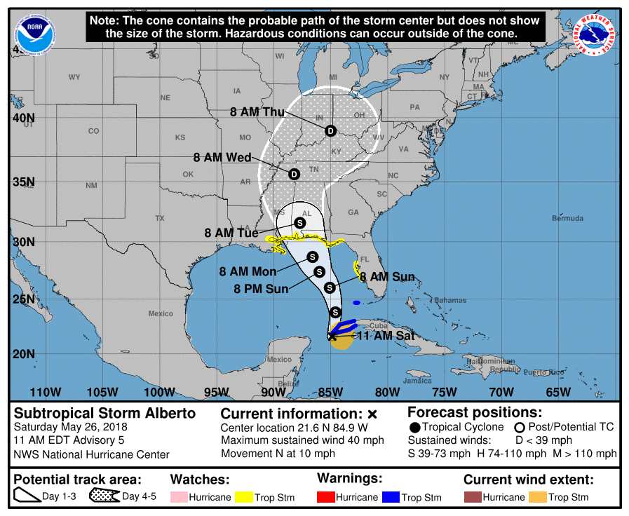
FORECAST... For the past three or four days, most of the models take Alberto and put the center between New Orleans and Panama City but remember from the discussion portion that people to the right of where Alberto makes landfall are going to have much greater impacts then to the left.
Alberto will begin to move to the north and northwest with time. It has about 36 hours after Saturday afternoon with low winds in the atmosphere and moist air to work with to strengthen perhaps.
Regardless, the odds of Alberto becoming a hurricane are relatively small and all the impacts will be to the east. In order from most to least likely, here are the threats:
Very heavy rain up to 12 inches in spots
Gusty winds, perhaps damaging in the central Gulf Coast
Tornadoes/waterspouts popping up (One or more tornado watches will be issued)
Lightning (Not very common in tropical cyclones)
If the models come to validate, Alberto will be making landfall sometime Monday and will slow down causing heavy rain in the southeast.
No comments:
Post a Comment