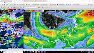
Conditions can come together for a possible episode of severe weather somewhere on the Florida Peninsula over Sunday afternoon or Sunday night. Depends on which model you look at. The two big ones have different answers:
Our question from last night has been answered. The Storm Prediction Center has placed most of Florida and southern Georgia under a marginal risk for severe weather Sunday. Just because they've done that doesn't mean the chance is minor. There is still a possible upgrade to a slight (standard) risk as the event gets closer in from the text in the outlook stated here:
Will introduce 5% severe probs for this scenario but a
   SLGT risk may be warranted for this region if confidence increases
   regarding this scenario.
Here's the Day 3 Outlook Map
... BUT NICE TOMORROW/SATURDAY: While most of the attention will be focused on the Sunday afternoon/evening event, the good news is that we will enjoy some calm weather for the next 48 hours. We are starting the day mostly in the 40s, but we rise into the 60s this afternoon. Pretty much the same deal on Saturday. The race at Daytona International Speedway Saturday night still could have some clouds but no organized storms expected.
GFS:
The GFS (American) model at 12pm Sunday (top image) shows the pattern at 500 mb (20,000 feet up in the atmosphere) a closed low south of St. Louis and energy coming from the northwest down through Mississippi/Alabama and Georgia. The CAPE (Instability) (It's on the top left) has leveled off now, the helicity has done the same and the Rain (Bottom left) doesn't show much which is indicative of isolated storms developing out ahead of the cold front.
4pm Sunday (Second Image) has the 500 Mb low open in the Missouri Valley (a good thing because when a low pressure is opened it can't dominate the weather pattern unlike otherwise) the instability is still present across the Florida area, the helicity is displaced from that (Also a good thing, those two want to be co-located together to get severe weather underway) and the reflectivity still has a broken pattern to it.
8pm Sunday (Third Image) has the 500mb low still open and pulling away from the southeast. The cold front if this is correct should start to come through late Sunday night and Monday morning.
If the GFS is correct, north Florida and southern Georgia will be under the risk more than the other parts of the state. But there is another model to look at....
NAM:
2pm Sunday: The 500mb low is over Missouri/Illinois much like the GFS. The instability values are creeping up on the peninsula (especially western part), the helicity is over north Florida (west of Jacksonville) and the projected radar has a line in the panhandle but any storms that develop out ahead of it will have the chance to go supercelluar and have a threat of large hail, damaging winds and a tornado or two.
8pm Sunday: The low begins to break apart but is still over Missouri and energy coming through all of the southern states. The air still is unstable across Florida and the wind shear is still present. the cold front has barely moved from its previous spots,
2am Monday: The cold front should start to clear the area from northwest to southeast. if this is right, the southern part of the state will have a severe weather threat Monday too.
One good thing about this run is that the significant tornado parameter (STP) and the supercell composite index values have come down some. This indicates that there is still lack of model run to run continuity so wouldn't be surprising to see this go back up later tonight.
The NAM is more aggressive of the potential (much like last night) but we are still two days away from the thing. No reason to get nervous about it yet. Just have a plan if severe weather strikes and if there is a warning, execute it.
The timing is the most important because if the dynamics are there during the daylight hours, all of the energy will be available but if it's too far north or waits until nighttime, maybe it'll just be a marginal day. We shall see. Still questions persist of when/how/where/why, but there is a chance there could be a severe weather event in the state Sunday afternoon and Sunday night, so keep an eye on these discussions as we get closer to the event. Remember also this is race weekend at St. Petersburg, so thousands of people will be out on the streets.
The timing appears to be from late morning Sunday to about 2-4am Monday morning but I will finetune a closer window in about 24-36 hours from now.
NEXT WEEK: Monday and Tuesday should be much like Tomorrow. Lows in the 40s with highs in the 60s, clear skies with a north breeze. Unseasonably cool for sure.
FIRE WEATHER: One more day of low humidity will keep the fire danger/outlook high across the area. Don't do anything stupid out there and if a fire develops, it could spread pretty rapidly particularly inland.


No comments:
Post a Comment